
File:Phantom islands in Southern Atlantic.jpg

Size of this preview: 800 × 592 pixels. Other resolutions: 320 × 237 pixels | 640 × 474 pixels | 1,024 × 758 pixels | 1,280 × 948 pixels | 2,716 × 2,011 pixels.
Original file (2,716 × 2,011 pixels, file size: 933 KB, MIME type: image/jpeg)
| This is a file from the Wikimedia Commons. Information from its description page there is shown below. Commons is a freely licensed media file repository. You can help. |
Summary
| Description |
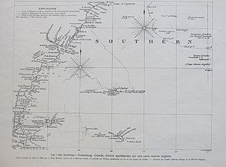
English: A 1929 presentation of an 1805/1806 map of the South Atlantic, including several phantom islands
Français : Carte avec une vue d'ensemble des de l'Atlantique sud. |
||||
| Date | |||||
| Source | L'Illustration, 24/8/1929 | ||||
| Author | Unknown author | ||||
| Permission (Reusing this file) |
|
||||
File history
Click on a date/time to view the file as it appeared at that time.
| Date/Time | Thumbnail | Dimensions | User | Comment | |
|---|---|---|---|---|---|
| current | 11:49, 5 November 2019 | | 2,716 × 2,011 (933 KB) | Tangopaso | == {{int:filedesc}} == {{Information |Description= {{en|1=Map with an overview of the phantom islands in Southern Atlantic.}} {{fr|1=Carte avec une vue d'ensemble des îles fantômes de l'Atlantique sud.}} |Source=L'Illustration, 24/8/1929 |Author={{unknown}} |Date=1929 |Permission={{PD-old}} |other_versions= }} Category:L'Illustration, 1929 Category:Old maps of phantom islands Category:Old maps of the Atlantic Ocean Category:1805 maps |
File usage
The following page uses this file:
Global file usage
The following other wikis use this file:
- Usage on de.wikipedia.org
- Usage on es.wikipedia.org
- Usage on fr.wikipedia.org